
Pacific Northwest Travel Diary
I. Portland

Portland, OR.
We began our trip in Portland, OR. Our first day was fairly low key—we met at the airport, picked up our rental car and checked into our hotel in downtown Portland. Once we got settled, we walked to the Portland Saturday Market on the Willamette River to get some food take in a bit of the city. Portland is well known for its food truck scene, so after perusing the numerous options, we settled on Greek gyros for lunch with salted-caramel ice cream for dessert. We also stopped off for a dozen fresh oysters at one of the local seafood spots on our way back to the hotel (oysters became one of the food staples of our trip).

“Keep Portland Weird”
The next day, we set out on our first excursion exploring the Columbia River Gorge about 40 minutes east of Portland. The gorge, formed by the Columbia River cutting through the Cascade Range, was known for its rich scenery and its impressive concentration of waterfalls.
This day was our first encounter with the famously rainy climate of the Pacific Northwest. We came prepared—both sporting rain windbreakers, water resistant hiking pants and boots/shoes. This helped keep us mostly dry and comfortable out on the trail.

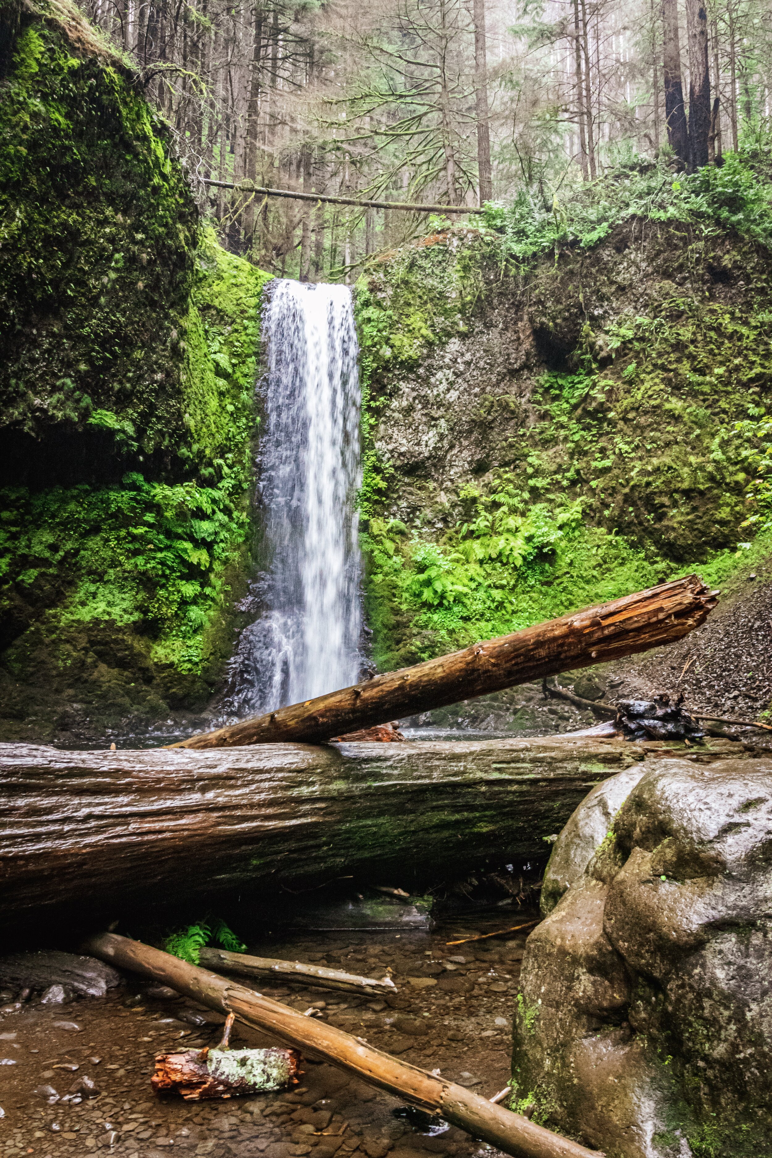
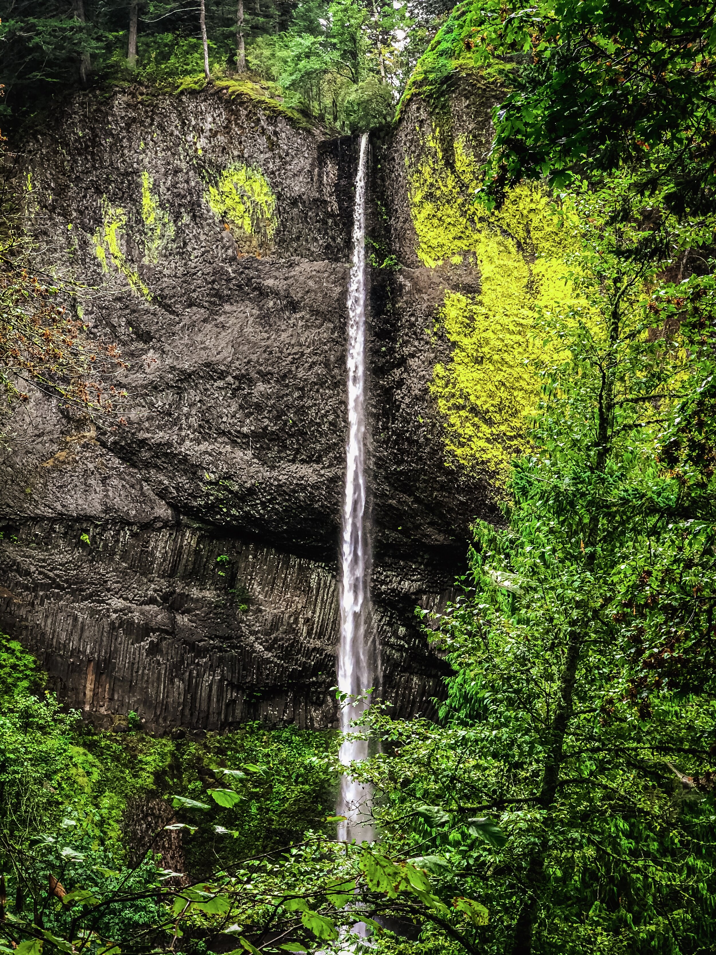
Multnomah Falls.
The first waterfall we visited was Multnomah Falls. At 620 feet, the two-tiered waterfall was stunning, with a top we could barely see through the clouds and mist. We hiked a short way to the bridge spanning the second tier to get a better look at the upper falls and then decided to hike to the very top. Situated alongside the falls, the trail was well-defined, with at least the first portion of it being paved with concrete, and then later, gravel. As we reached the higher sections, the trail began to switchback on itself and the drop-offs to the side became more and more dramatic. The trail offered up some amazing views of the gorge, with a healthy amount of vertigo mixed in for good measure.

Through the mist: the other side of the Columbia River Gorge.
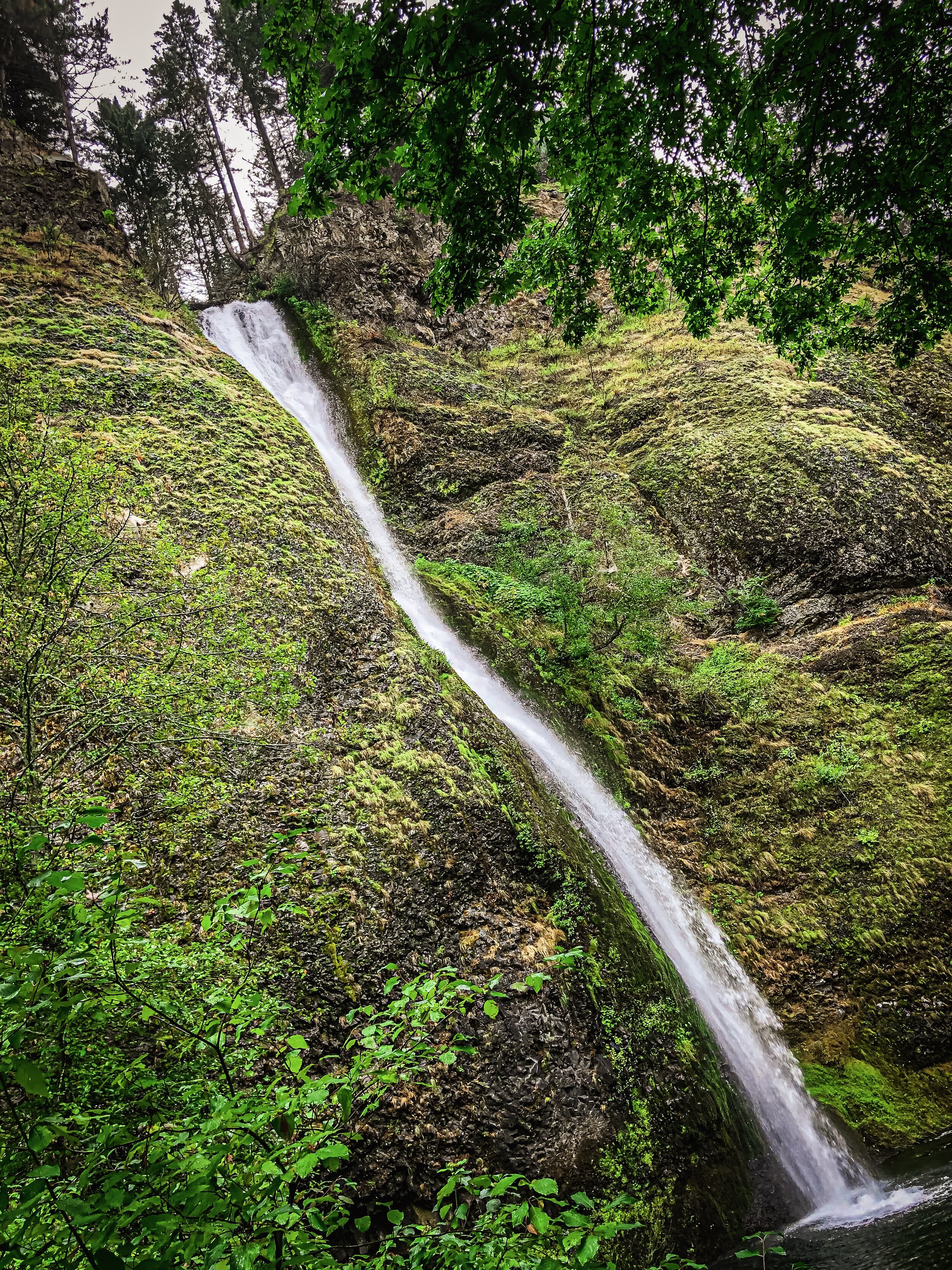
Once we got to what we thought was the top, we entered into a flatter section that wound its way through the forest. The rain had become steady, but we’d heard from some hikers that there was another small waterfall about a half mile further along the trail, so we kept walking. We soon came to what we would later find out was Ecola Falls; a lovely waterfall fed by Ecola Creek (which ultimately feeds Multnomah Falls). We climbed down a small embankment and put our water gear to the test, straddling a large fallen log and bouncing over a few rocks and about an inch of gently flowing water to walk right up to the pool at the bottom of the falls.

The 620 foot plunge to the bottom of Multnomah Falls (parking lot in the mid-upper right and pedestrian bridge in the mid-lower right for scale).
We enjoyed the view for a bit, and then decided to start back. We came to a junction we had passed before where we realized we had missed the sign pointing to the summit of Multnomah Falls—which was actually what we had come to see— so we went that way. It was about another third of a mile down to a viewing platform built roughly 25-or-so feet right above the top of the falls. The view, though obscured by mist, was dizzying— particularly once we caught a small glimpse of the tiny cars in the parking lot below. I said to Amanda how funny it was to me that people would think building a platform on top of a 620 foot waterfall was a good idea, even if it was solid. We took a few pictures and then retreated back to the safety of solid ground.
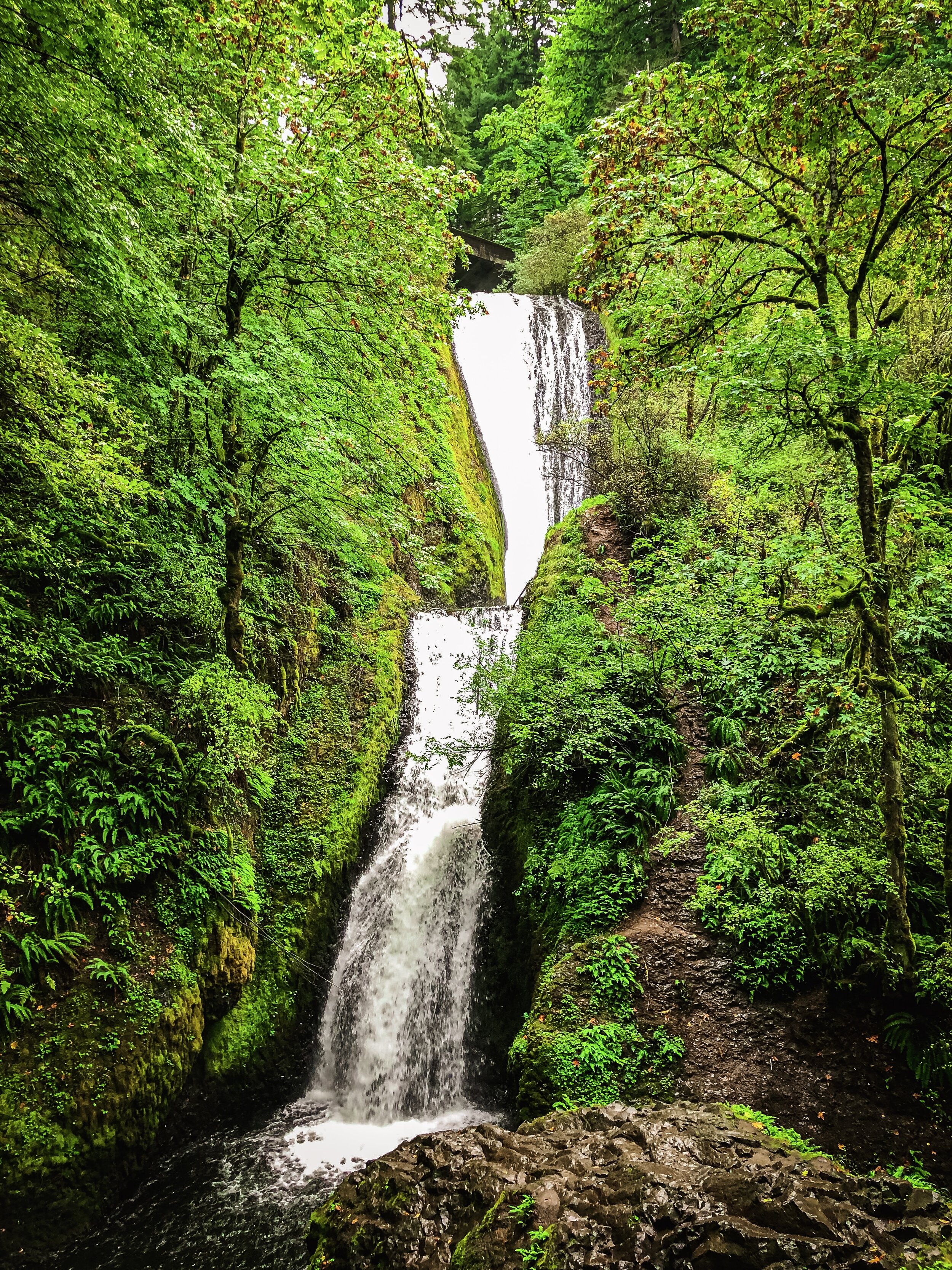
From left to right: Ecola, Horsetail, Bridal Veil, Wakina and Latourell Falls.
Once we got back to the car, we set out to view some of the other waterfalls in the area. The decision was tough, given that there are over 90 waterfalls in the Columbia River Gorge. Some of the ones we had hoped to see were inaccessible because of damage caused by the Eagle Creek Fire of 2017. The fire was set by a 15-year-old teenager playing with fireworks and burned approximately 50,000 acres. The boy in question was put on probation, given thousands of hours of community service, and ordered to pay tens of millions of dollars in damages to the state of Oregon for the incident.

A panorama of the Columbia River Gorge
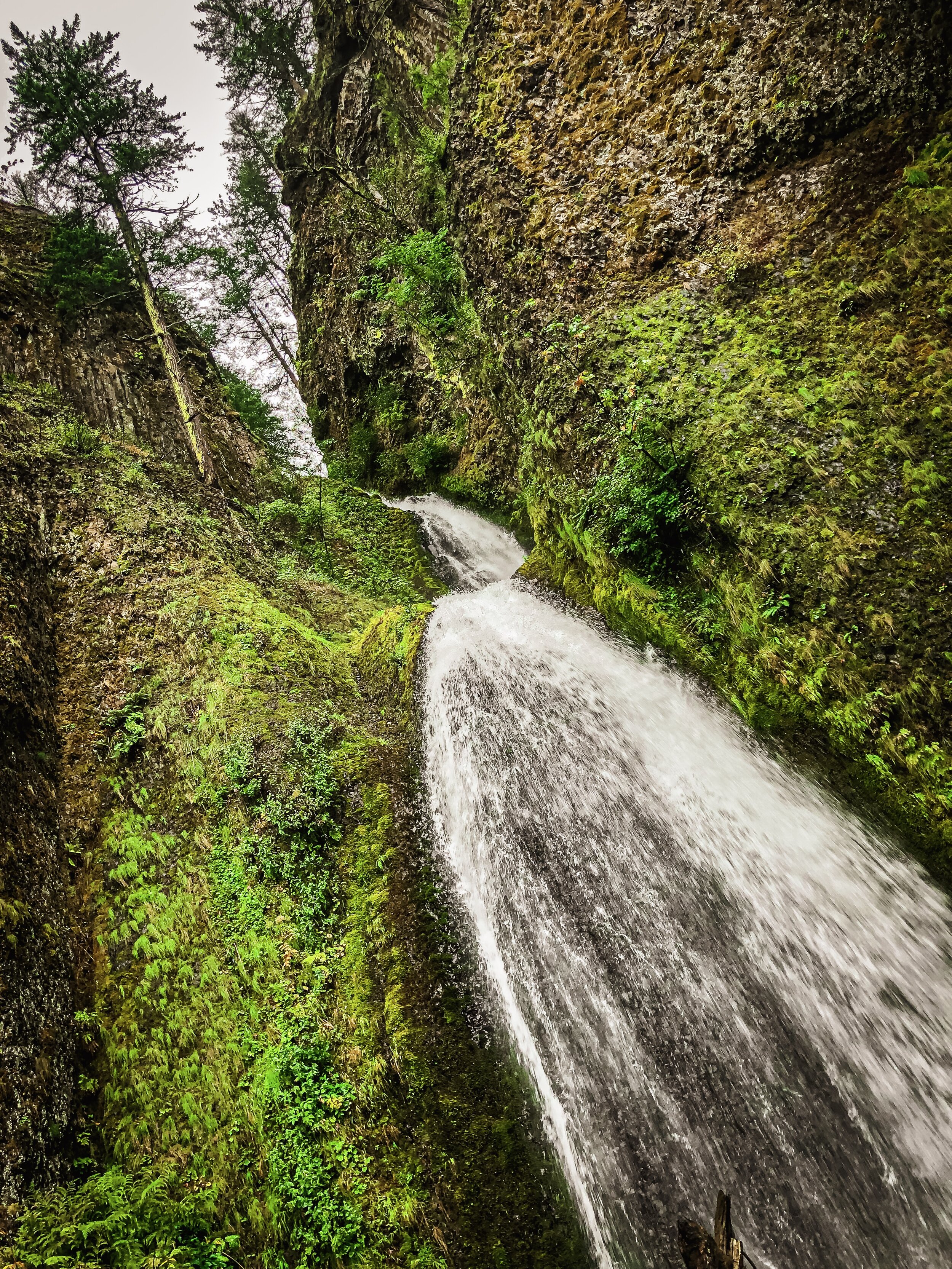
Latourell Falls was our last stop before heading back to Portland for the night. There was a short trail to reach the bottom of the waterfall that gave us the opportunity to climb down a shallow embankment to the base. The waterfall itself goes over a cliff at a height of 250 feet and drops straight down to the rocks below. When I looked this up later, I found out that it does this without tumbling along the cliff, which makes it unique among the waterfalls of the Columbia River Gorge (and which is probably why it why it was my favorite). We took some photos and scrambled over some rocks to walk right up to the pool at the bottom—close enough to feel the spritz and spray of the water as it careened over the cliff.

Amanda and Latourell Falls.
II. Crater Lake

A box of Voo Doo donuts.
Our last morning in Portland, we made a pilgrimage to the famous “Voo Doo Donuts” to get a dozen of their decadent, over-the-top donuts. Since it was a Monday morning, the usual line out there door was practically non-existent, so we were able to quickly grab a box and sit outside with coffee trying different flavors. We sampled many different kinds of donuts including one with maple-frosting topped with bacon and one with mango jelly filling. We couldn’t possibly eat them all in one sitting, so we snacked on them for breakfast the next few days.

The trail to Mirror Lake at Mount Hood.
This was the first driving day of our journey. It happened to involve covering the greatest single distance of our whole trip— about 230 miles or so to Crater Lake. We had hoped to see Mount Hood on the way, so we picked a short hike to do called the “Mirror Lake Loop” in the shadow of the mountain. The end of the hike had a small lake which was known for giving a mirror-like view of the mountain in the water’s reflection. Unfortunately, the cloud cover on this day was heavy and we weren’t granted even the smallest glimpse of the peak. The trail itself was a pine forest connected by a series of well-maintained bridges over small babbling brooks and creeks. After a while, it switched back and climbed moderately until it lead us to the loop around the lake. The waters were still and calm and there were very few people around. We hadn’t intended to actually hike the trail around the lake but, seeing that it was only about a half mile, we decided to go for it. Amanda spotted some crawfish/crayfish hanging out in the shallows and almost managed to avoid scaring them off.

Mirror Lake in the shadow of a hidden Mount Hood.
After our detour, we continued on to the south. Along the way, we got to experience the diverse array of Oregon’s landscapes. The view outside of the car was kaleidoscopic—beginning with sparse coniferous forest that morphed into dry rolling grasslands, and then transforming completely into to deep canyons and lush farmlands set against distant snow-capped mountains.


We arrived at Crater Lake right around sunset. Because the lake is within the confines a volcanic crater at over 7000 feet of elevation, there’s no ability to see it as you approach. Our first actual look of the water came at Merriam Point on the north rim. The lake was immense and grand and we felt elated to have finally arrived.

The entrance to Crater Lake.

Arriving at Crater Lake at sunset.
That was quickly tempered of course by our realization that the rim road that loops the crater, while well maintained, had some parts that felt precarious and extremely difficult to navigate at dusk with the sun in one’s eyes. The road was almost completely devoid of guard rails (something we joked about throughout the trip; the fact that the National Park Service doesn’t really care for guard rails in ANY of their parks). I took over driving at this point, since my eyes seemed to handle the glare of the setting sun better than Amanda’s (despite her valiant effort). We stopped at a few more viewpoints along the western side of the lake and took in the sunset view over the mountains before making our way to the Crater Lake Lodge in the Rim Village for dinner.

The Milky Way at Crater Lake.
The lodge was warm and inviting with a massive hall and roaring fireplace leading to a restaurant. We spent some time there before having our dinner. I was dreading having to drive down the rim road in the dark to the “Crater Lake Resort” (our final destination for the night) so Amanda asked if there were any vacancies in the hotel where we were already eating. Unfortunately, they were full up—though we did later meet a couple from Queens, NY, who had managed to book a room at the Lodge only two weeks previously when we had tried months out with no success.
After dinner, we went outside and were greeted with an absolutely magnificent night sky—potentially the clearest either of us has ever seen. The stars were countless and the Milky Way was in full view to the naked eye. The night sky only became more brilliant as our eyes adjusted to the darkness. The clarity was such that we were mesmerized by the continuous stream of shooting stars that we could see. I was able to get out my astrophotography lens to snag a few shots—only later realizing that I had the wrong aperture setting, so I could’ve gotten even MORE starlight than I ended up getting (but the at least a few of the shots were salvageable).

The night sky.
We stargazed for nearly an hour before we finally decided to head to the resort in the tiny town of Fort Klamath south of the lake. Leaving the Rim Village, the road down was quite curvy with a number of switchbacks that we took very cautiously, not really being able to see much beyond the reach of our high beams. The area is so remote and the cell service so poor, we almost missed the turn to our lodging, but eventually found our way to our cabin and called it a night.
The next morning, we were eager to get our first look at the lake in daylight, so we headed north to Mazama Village near the south entrance of the park to fill up on gas for the day’s journey. Our first stop was the Cleetwood Cove trail on the north side of the crater rim.

Crater Lake in the daylight.
At this point, it’s worth noting a bit of the history of Crater Lake: it formed about 8,000 years ago when the top of Mount Mazama erupted and collapsed in on itself a cataclysmic explosion. It was so catastrophic that it’s been seared into the oral tradition of the Native Americans in the area whose ancestors were actually witnesses to the event.

“Wizard Island.” So-called because of its resemblance to a wizard’s hat, it’s a cone of volcanic cinder rising 2,700 feet from the floor of Crater Lake.

The hike down to Cleetwood Cove.
Over the millennia, glacial melt and rainwater slowly filled up the crater, gradually transforming it into what would become the deepest lake in the United States with a max depth of 1,949 feet. Because the lake has no inflowing streams or rivers, the water is pristine and and unpolluted making it some of the clearest and purest water in the world. The lake receives about 45 feet of snow per year, which keeps its waters perennially well-supplied.
We also learned an interesting factoid from Ken Burns’ National Park documentary that an 8-inch disc is still visible from the surface even submerged to a depth of 142 feet.
Lastly, the first settler to glimpse the lake was a man by the name of John Wesley Hillman in 1853. He was born in Albany, NY and moved to New Orleans at age 16. I thought it was quite the coincidental intersection of mine and Amanda’s story since I’m from Albany and we got married in New Orleans.
Cleetwood Cove on the north rim is the only trail that allows hikers access to the water, so for us, it was a “must see.” The hike is only a little over 2 miles with a pretty steep climb on the way back up, but we thought it was well worth it to be able to put our feet in the water.

The far side of Crater Lake.
It wasn’t until the sun was shining on the lake that we could truly appreciate the lake’s deep cerulean blue color and clarity. We kept stopping at various points on the hike down to snap pictures, in awe of the views we were getting.

A moment of reflection.
Once we got down to the bottom and sat ourselves down on the rocky beach, I took my boots off and walked right into the water. It was ice cold and I almost slipped on the rocks and fell in, but managed to regain my balance. Swimming was allowed at this spot, but I was glad I didn’t fall in because my phone was still in my pocket.

Amanda taking in the lake.

Cleetwood Cove.
After dipping our feet in, we walked a little further down the beach to a spot that gave us a wider view of the north rim of the crater from the top of a 25-foot cliff. This was a known cliff jumping spot, and though I was sorely tempted by the azure blue water, I hadn’t brought my bathing suit, so we just settled for asking a few folks to take our picture instead.
Before we started the hike back up, we were impressed to see a father and son get in the water at the beach where we had put our feet in, though we didn’t envy how icy cold it must’ve been.


Phantom Ship Rock.

A close up of Phantom Ship Rock.
Next and last up on our drive around the rim was “Phantom Ship Overlook.” This viewpoint gave us a great look an interesting rock formation referred to as the “Phantom Ship” that’s actually a hydrothermal feature rising from the lake floor. It gets the name because of its resemblance to a ghost ship, particularly on foggy nights on the lake. We took a few snapshots and pressed on to the Rim Village for a quick lunch and one last look at the lake before heading to the Oregon coast.
III. Brookings to Newport
Our drive from Crater Lake to Brookings took us in a southwesterly direction through the mountains about 175 miles. Because of the direction that the road went, we actually had to cross into California for a spell before heading back into Oregon. The section of highway that cut into California was nestled in a valley between some steep mountains. This meant we got to drive some very fun, curvy and winding roads to round out the drive.

Sunset in Brookings.
As we crossed back into Oregon, the road began angling toward the coast and the sun began to set. It wasn’t long before we caught our first glimpses of the Pacific Ocean. Having driven through mountainous terrain for the previous two days, it felt pretty momentous to finally reach the coast.

A closeup of the sunset in Brookings.
We arrived at Brookings just in time to capture some absolutely stunning sunset photos from the beach down the street from our hotel. The colors were dazzling as the sunset progressed and I think it’s safe to say that we did not see a more spectacular sunset during the rest of our trip.
We headed into town for a quick dinner at a local pub and then back to the hotel to do some laundry. This was a necessity because there was no way we could have packed enough outfits for the amount of time we had planned to be on the road— so Amanda found us a place to stay with laundry on-site. We were extremely disappointed to discover upon returning to the hotel that they didn’t provide air conditioning as amenity (apparently a norm on much of the Oregon coast). This was a huge letdown given that our room was on the top floor of the complex and our thermostat read eighty degrees when we arrived and remained at that temperature for the duration of our stay. We were encouraged to open the patio door and use the box fan they provided to cool the room. With the door open, we could hear the waves of the ocean crashing in the distance and it cooled down a bit, but it also ended up letting in a bunch of gnats and other bugs, which was less than ideal.
The next morning, after a fitful sleep, we enjoyed a continental breakfast before setting out with coffee in hand to Newport, OR.

The Oregon Coast.

Left: Big Sur, 2014. Right: Oregon Coast, 2019.
Our first set of stops was in the Samuel H. Boardman State Scenic Corridor, which offered a number of beaches, hikes and vista points along a 12-mile stretch of breathtaking Oregon coastline. We had initially intended to do a short walk to Cape Ferrelo viewpoint, but instead (mistakenly) ended up doing a 2+ mile hike through the forest that took us almost all the way to the next viewpoint at House Rock. The hike itself didn’t afford many views of the ocean once we entered the forest, but it was still a peaceful nature walk and a good workout. Along the way, I attempted to recreate a shot I took of Amanda during our California trip through Big Sur in 2014 from memory with decent results.

The view from House Rock.

Natural Bridges.
Our next stop was “Natural Bridges.” A short walk down to a viewing platform presented us with a view of two erosion-carved natural rock bridges standing tall amongst the waves crashing several hundred feet below. We actually thought there might be more to the trail beyond the platform, but realized it was far too narrow and precarious given how close it was to cliff’s edge, so we decided not to chance it and headed back to the car.

The Whale’s Head rock formations.
We drove on to Whale’s Head Beach a few miles up the coast. Nestled in a cove with evergreen trees perched high on a cliff overlooking the striking rock offshore formations, Whale’s Head was practically deserted when we arrived. We spent a good forty minutes here walking along the shore, examining rocks and enjoying the solitude and the sound of crashing waves.

The surf at Whale’s Head Beach.
After Whale’s Head, with a fair amount of driving ahead of us, we pressed on. We stopped briefly at a few other beaches including “Battle Rock” (site of a famous battle between the Qutnomah Indians and settlers), “Face Rock” (so called for a rock formation off shore that resembles the outline of a face) and a windy and desolate stretch of beach called “Devil’s Kitchen” before finally arriving in Bandon, OR.

The “Devil’s Kitchen” streaked by windblown sand.

“Face Rock”
Bandon is a sleepy, but popular seaside town on the coast with a population just over 3,000 people. When we arrived, we went straight to the famed “Tony’s Crab Shack” where we enjoyed our second dozen oysters, along with crab hoagies and clam chowder. This satiated our seafood craving and gave us fuel for the remainder of the drive to Newport.

Crab hoagies and oysters.

Amanda presenting our meal.
We spent the rest of the afternoon driving through evergreen forests and along dramatic coastline, arriving in Newport around sunset. Our hotel for the night was a unit at the Condos at Nye Beach. We had hoped to actually catch a view of the sunset, but the gentleman at the front desk, courteous as he was, was quite a talker and required some help from his supervisor checking us in.
Our condo was situated on a bluff overlooking the beach and the ocean. Though it lacked air conditioning like the hotel in Newport, it was quite nice (and considerably cooler). We had dinner at a gastropub down the street and then walked back to the condo. Amanda went to bed and I used the access code we had been provided to follow a lit staircase down to the beach. It was a serene experience standing alone in the darkness listening to the breakers crashing against the shore as a fog rolled in off the ocean— a peaceful end to a long day.

Sunset in Newport, OR.
IV. Newport to Astoria
It was cloudy the next morning, but in the daylight, we were able to more fully appreciate the sweeping view of Nye Beach we had from the condo. As we got our things together, we found a guestbook that we paged through. Some recent visitors said they had spotted whales right from the living room. We didn’t have any such luck, but we signed the guestbook just the same. We had a quick continental breakfast and took coffee down to the beach for short walk before setting out on our journey north toward Astoria. Just before leaving town, we stopped briefly to photograph the starting point of US Route 20—a route that runs all the way from Oregon to Massachusetts, through both my mom’s hometown of Auburn, NY and also through my hometown of Albany, NY. My family and I took the route frequently between the two cities I was a kid.

Nye Beach.

The start of US Route 20.
Our first stop of the day was Cape Meares State Park, which featured one of the many defunct lighthouses dotting the coast of Oregon. We walked a short, fenced-off trail along the edge of the cliff to a scenic viewpoint and snap some photos.
Our main destination between Newport and Astoria was the Tillamook Cheese Factory in Tillamook, OR. This could’ve been described more accurately as a “pilgrimage” since Amanda and I have been huge fans of their cheddar cheese for as long as we can remember and have enjoyed eating it at home and in the Tillamook branded cheese plates that Delta Airlines offers.
The factory facility itself was very visitor-friendly. We were walked through the various steps of the cheese-making process with a real-time view of the factory floor from above. We saw cheese being packaged and checked for quality by staff before being shipped out.

The Tillamook Factory.

A Tillamook grilled cheese and tomato soup.
We visited a tasting station where we were able to sample little cubes of different flavors of Tillamook cheese and also went to the food court where indulged in a signature Tillamook grilled-cheese with tomato soup. We decided to skip the Tillamook ice cream that they were serving, though we were sorely tempted. Amanda got a shirt from the gift shop to commemorate the experience (and, unfortunately, a bit of a stomach ache from all the dairy we had consumed).
After our visit to the factory, we stopped at another beach called “Hug Point.” Here, we scrambled along the base of a barnacle-encrusted sea cliffs and explored a tidal cave cut by the waves. At high tide, the cave as well as the beach itself would have definitely been completely flooded, but since it was low tide, we were actually able walk inside and see huge pieces of driftwood and deadfall that had been left there by the receding water.

“Haystack Rock” from Ecola State Park.
After Hug Point, we stopped at the popular Cannon Beach to see one of Oregon’s most famous offshore rock formations: “Haystack Rock.” It was impressive to view, but it was relatively crowded. We had become spoiled by the number of uninhabited beaches we had gotten to experience on the coast, so we didn’t linger long.
North of Cannon Beach, we made a quick stop at Ecola State Park, which was the site of scenes from both “The Goonies” as well as Arnold Schwarzenegger’s “Kindergarten Cop.” Unfortunately, the viewpoint we had hoped to visit had been damaged by erosion and was permanently closed—though we were able to look south to get a better vantage point on Haystack Rock.


As we were leaving Ecola, we came back out on to one of the main roads and noticed several cars had pulled over and were blocking traffic. Once we got closer, we realized that a herd of elk had taken over the middle of a residential street and were grazing on hedges and flowers in front of people’s houses. We immediately whipped out our cameras and started taking pictures to capture the scene.
The herd itself was predominantly female with two males—one with a large set of antlers and one with a smaller set. The smaller male elk kept trying to get close to the rest of the herd, but the larger male wouldn’t have it and led a lively chase to ward him off. They never came to blows, but it was entertaining to see them jockeying for position.
The elk themselves were quite large— much bigger than standard deer, so we stayed in the car and kept our distance. Passing drivers were very careful to drive slowly so as not to frighten the herd, though none of the elk seemed bothered by the presence of so many cars idling on the side of the road. We must’ve watched them for 30 minutes or so, snapping pictures all the while, before we left.

The Peter Iredale in Seattle in 1900 (Wikipedia).
Our final stop before heading to Astoria for the night was Fort Stevens State Park to see the remnants of the wreck of the Peter Iredale. How it came to be wrecked on the beach (along with what it used to look like) is recounted below from Wikipedia:
“Sailing from Salina Cruz, Mexico, on or about September 26, 1906, Peter Iredale was bound for Portland, Oregon with 1,000 tons of ballast and a crew of 27, including two stowaways. The voyage up the coast was unremarkable until the night of 25 October, when Captain H. Lawrence sighted the Tillamook Rock Lighthouse at 3:20 a.m. local time. The crew altered course first east-northeast and then northeast to enter the mouth of the Columbia River in thick mist and a rising tide. Under strong winds out of the west, an attempt was made to wear the ship away from shore, but a heavy northwest squall grounded Peter Iredale on Clatsop Sands (now called Clatsop Spit). High seas and wind drove the ship ashore. A lifeboat was dispatched from Hammond, Oregon and assisted in evacuating the sailors, who were tended to at Fort Stevens. No casualties occurred in the accident.”

Sunset at Fort Stevens State Park. The remains of the 113-year-old wreck of the Peter Iredale in the foreground.
We arrived at the wreck just in time to catch the sunset. It was eerie to see the ribs of the ship’s rusty skeleton protruding from the sand on an otherwise featureless beach, but remarkable given that the fragments that remained had survived over 113 years in that very spot. I couldn’t help but think that it was clear the ruin wouldn’t survive another 100 years, so we were lucky to get to see it before it was ultimately reclaimed by the elements.
Weary from a long days’ travels, we made our final push to the city of Astoria— now only a few miles away. We checked in to our lodgings at a quaint, but nice hotel called “The Commodore” in downtown Astoria and went immediately to dinner at a seafood restaurant around the corner.
On our way back to the hotel, we had hoped to grab a nightcap at the hotel bar, but apparently the waitress had closed up for the night (though she was still chatting with a guest). Amanda managed to find out from the concierge that the guest in question was a local of “Goonies” fame and he was entertaining the waitress with war stories surrounding the film, which was why she said the place was “closed” when it still appeared open. We found it a bit amusing, if annoying, but the concierge snuck us a few drinks anyway even though it was after hours. We were charmed by his hospitality (probably the best we had all trip) and went to the roof deck of the hotel to enjoy them. The roof deck itself had an outdoor fire pit that kept us warm and cozy until we went back to our room to call it a night.

Astoria, OR at night with ships off shore.
V. Astoria to Mount Rainier
The next morning, we enjoyed another continental breakfast in the lobby of the hotel complete with egg frittatas and warm cinnamon buns, as well as copious amounts of coffee. Our first stop of the day was Fort Clatsop just outside of Astoria. This was the site where explorers Lewis and Clark wintered between 1805 and 1806. The actual fort itself is long gone, but a replica has been built in its approximate location and is now administered by the National Parks system. The reconstruction allowed us to get a sense of what it would have been like to have experienced this land when it was relatively uninhabited.

Fort Clatsop (replica).

Inside Fort Clatsop.
The fort itself was small and compact. Lewis and Clark’s quarters were faithfully recreated with beds, desks and trinkets of the period. So too were the barracks where the rest of their party slept in bunk beds. They also had recreated the private suite that their translator/guide Sacagawea and her child resided in. If we had to guess, staying in place like Fort Clatsop for the winter would have been a mighty cold proposition, even with a roaring indoor fire.
After visiting the fort, we had intended to visit Mt. St Helens on our way to Mount Rainier, but when we checked the St. Helens’ webcam to see the conditions, the view was completely covered with clouds. Since visiting the mountain would have been a detour of several hours, we decided it wouldn’t be worth all of the effort to divert if we weren’t going to get to see it, so we decided we’d skip it and head straight to Mount Rainier.

The Lewis and Clark Bridge into Washington.

Entering Washington.
It was at this point, after having spent a week traversing steep, winding trails, deserted beaches, majestic waterfalls, and tranquil forests and the like, that we left the State of Oregon to head into Washington for the next phase of our trip.

The Nisqually entrance to Mt. Rainier Nat’l Park.
Washington is known as the “Evergreen State” and we did notice many telltale signs of the prevalence of the logging industry on our drive. We saw lumber yards and lumber mills as well as whole sections of mountain forest stripped bare in various stages (it reminded me of an unfinished buzzcut).
Though the Mount Rainier webcam had shown it to be clear when we left Fort Clatsop, as we drove, the clouds became more and more numerous until the sky was completely overcast and drizzly by the time we arrived at the Nisqually entrance to the park.

The “Trail Of Shadows” loop.
We first visited the small museum at Longmire that walked us through some of the history of Mount Rainier—both geological and cultural. We learned that Mount Rainier was the first National Park to experiment with incorporating scenic roads built for automobiles into the park layout. In fact, one of the nearby buildings had the remnants of an old gas station where some of the park’s first automotive visitors used to fill up.
We decided to hike the short “Trail Of Shadows” loop near the museum, given that the conditions were cold and rainy and the trail was short. Mount Rainier is an active volcano, and, as such, it has its fair share of geothermal activity—including hot springs. The “Trail Of Shadows” loop took us through forest and marshland past several of the defunct therapeutic spas and stoneworks that had been constructed when the park drew its first visitors in the 1800s. In several places on the trail, we saw (and smelled) carbon dioxide and sulfur gas bubbling up through the rocks and water— products of the super hot magma miles below the surface.

A long way down to the Nisqually River.
When we got back to the car, we decided that we’d head up to Paradise, which had a large visitors’ center and a number of trails that were supposed to offer great views of the mountain. The road up was initially fairly straightforward, but as we began the climb to Paradise’s 5,400 feet, the curves became sharper and the drop offs became more dramatic and hair-raising. We stopped at a few spots to appreciate the view, while simultaneously being humbled and terrified of the long, long way down.
When we finally arrived at Paradise, we were met with double disappointment— first with the realization that the Visitor’s Center was closed for the day (our phones had long since lost service, so we had been unable to look up the hours), and second with realization that the mountain was completely encased in clouds and hidden from view. It having already been a long day to get to Rainier, we decided to cut our losses and head down to the hotel for the night.

Mount Rainier remains hidden.
We stopped at an excellent little restaurant called “Copper Creek” just outside of the park where we had a delicious dinner with copious side servings of blackberry butter (the restaurant is known for their assortment of blackberry products, including blackberry pie).
Our hotel for the night ended up being only about a mile down the road from Copper Creek. While our accommodations were nice and situated in a private cabin that had very recently undergone renovation (including the installation of an almost comically large flat-screen TV), we quickly discovered that hundreds of gnats had taken over the room. This was more of a nuisance than a serious problem, but, while watching TV, we tried to squash as many of them as we were able to to stop them landing on us in our sleep. It was a healthy reminder that most of the lodging in and around national parks tends to lean more “rustic” than “chic.”
VI. Mount Rainier to Port Angeles/Olympic National Park

Still looking for the top.
The next morning after a pretty restful sleep, we woke up to see that the rain had stopped and that the webcam at Paradise was showing Rainier to be intermittently cloudy with windows of clarity. Not wanting to pass up a chance to see the mountain firsthand, we ate a speedy continental breakfast and then took off for Paradise.
Again, on the drive up, the clouds continued to dominate our view—granting us ever so small glimpses of the snowy slopes of the mountain here and there. Mountains like Rainier are notorious for generating their own weather since moisture in the air condenses into clouds as it’s forced to higher elevations. As we drove, I expressed some concern that we may not get to see the mountain at all after given that the clouds had completely denied us the day before and didn’t look to be breaking on on this day, but fortunately, that was not the end of the story.
When we arrived at Paradise, we parked our Jeep and headed into the Visitors’ Center just as it was opening. The building was an open and airy lodge that was practically brand new. There was seating and a help desk on the ground floor and exhibits in the upstairs mezzanine (I personally always appreciate seeing my tax dollars put to good use in maintaining these beautiful parks and their facilities in this way). There had been a bit of snowfall in Paradise overnight—about a half an inch, so Amanda spoke to one of the park employees to see what their recommendations of the day were for trails in the area given the conditions. Though most of the trail network in the Paradise area is paved, we saw an information placard advising that the area is prone to unexpected and rapid weather changes—including snow white outs (they actually had a picture showing this). The placard also said we should be prepared for an unexpected night out on the mountain. With that in mind, we dressed as warmly as we possibly could and brought food and water and, of course, our trusty Garmin “In-Reach” satellite locator.

The alpine meadows of Paradise.
It’s worth noting here a bit about Paradise. The area is largely a sub-alpine meadow that is known for spectacular wildflower blooms at certain times of year, but still displays vibrant colors in the off season. Celebrated naturalist and conservationist John Muir (who singlehandedly spearheaded the creation of the National Park system—first in Yosemite Valley in California, and then other places like the Grand Canyon and Mount Rainier) is quoted in 1889 as saying that Paradise had “the most luxuriant and the most extravagantly beautiful of all the alpine gardens I ever beheld in all my mountain-top wanderings.”
It’s worth also noting that Muir also summited Rainier before the advent of the modern trails people use today. Afterwards, he wrote a letter to his wife stating “I did not mean to climb it”—such was his enthusiasm for nature that he couldn’t stop himself from doing so. The base camp that climbers use today to launch their treks to the summit is named “Camp Muir.”

Rainier looms large.
As we began our hike, the cloud cover on the mountain slowly began to lift. Though the trail was blanketed with light snow and it was fairly cold, our blood got pumping as we ascended and we warmed up quickly. Before long, we were face-to-face with Mount Rainier.

Posing with the mountain.

Rainier in panorama.
At 14,411 feet, Rainier was colossal and awe-inspiring to finally see. We managed to set up our camera tripod to get a shot of us with the mountain and managed to hang in long enough in the face of the bitterly cold wind to get a few more shots—including one of the Nisqually glacier flowing off of the mountain.

The Nisqually Glacier.
The trails in the area were heavily trafficked by amateur and seasoned hikers alike. In the midst of it all, we saw saw marmots (something like a cross between a beaver and a ground hog) casually foraging in the alpine meadow, completely unbothered by all the people stopping to observe. This squared with our other national parks experiences where the animals tended not to display any fear of humans because of their protected status

A marmot casually foraging the alpine meadows of Paradise.
As we started the hike down, the conditions began to deteriorate— so much so that by the time we arrived back at the Visitor’s Center, the mountain was once again covered in clouds and it had begun to snow. Our Paradise trek had been perfectly timed because we did not see Rainier’s peak again while we were in the park.

Amanda next to an enormous tree in the Grove Of The Patriarchs.
Next up, we took to the precarious roads ringing the north side of Rainier so we could visit the “Grove Of The Patriarchs.” This particular grove was known for having some of the largest and oldest coniferous trees in the park.
The grove was located on an island accessed by a short drawbridge in the middle of shallow Ohanapecosh River. Since the trail was fairly flat, we found it to be very crowded. That being said, it was a pleasant nature walk and we saw some impressively massive Douglas firs, hemlocks and cedars—some in excess of 1000 years old. They made us feel tiny by comparison.

The Ohanapecosh River.
After hiking the grove, we still had a good amount of ground to cover to make it to our hotel for the night, so we got going. We arrived in Port Angeles around dinner time and checked into a hotel called the “Red Lion Inn.” After dropping our bags, we headed up the street to a spot called Kokopelli Grill where we enjoyed a delicious locally-caught seafood dinner. After a long day, we went back to the hotel and called it a night.
VII. Forks and Hoh Rainforest
The next morning, we grabbed coffee at a small coffee shop and filled up on gas before heading up the road about 10 miles to the entrance of Olympic National Park. Our plan was to go to “Hurricane Ridge” to hike some of the trails that were supposed to showcase some great views of the Olympic Mountains. Unfortunately, when we got to the gate, we discovered that Hurricane Ridge Road that led into the park was closed due to snow and ice that had yet to be cleared from the road. This was disappointing, but not unexpected given the fickleness of mountain weather.
We headed back down the road and continued on our way west on Highway 101. Since we had missed out on Hurricane Ridge, we decided to stop and do the short hike to Marymere Falls on our way to the Hoh Rainforest on the far side of Olympic National Park. The hike was a nice and easy 2 mile loop through some lush forest with a terrace overlooking a nice waterfall at the halfway point.

Marymere Falls in Olympic National Park.

“Welcome to Forks, WA”
After hiking the trail, we stopped for lunch in Forks, WA. Forks is a small lumber town that happens to receive a tremendous amount of rain each year (among the most in the United States). As such, it inadvertently became the unlikely setting for the teen vampire romance book series “Twilight” by Stephanie Meyer. Meyer figured vampires would be inclined to avoid the sun and, after a quick Google search, discovered Forks and figured it would be an ideal location to set her book series (despite never having visited). After the books achieved international success they were, in turn, transformed into a multi-million dollar blockbuster movie franchise, Forks became a mecca for Twilight fans, generating a massive tourism boom that has since become the town’s primary business. (We subsequently discovered that Portland and Port Angeles had both been shooting locations in the film series, as well as Multnomah Falls from our visit to the Columbia River Gorge).
The town of Forks itself is incredibly small and when we visited, we didn’t find any vampires. In fact, it was a pretty day and the sun was out, despite the town’s reputation for being endlessly rainy. We had a quick meal at a local diner and then continued on.

“Young” trees growing in a row on a “nurse log.”
We arrived at Hoh Rainforest mid-afternoon. Hoh is a temperate rainforest that receives over 12 feet of rain per year. As a result, it is dominated by huge coniferous trees and covered almost entirely in different forms of greenery (saplings, mosses etc). We learned because of the prevalence of vegetation in the forest, young trees have a hard time finding space to grow. As a way to compensate, many of them will attach to, and grow out of, fallen and decomposing trees called “nurse logs.” These are easy to spot since the trees that grow this way often grow in rows and have either a log woven into their roots or a space where the rotting nurse log used to be.

Old growth forest in Hoh.

A tall tree in Hoh.
We saw young growth forest that had experienced variable conditions over the centuries resulting in shorter and thinner trees. We also saw old growth forest with much taller and thicker trees that had been largely undisturbed in their development. On the last leg of the trail, we entered the “Hall Of Mosses,” a section of the old growth forest where the trees were covered in lush, carpet-like green moss that was quite a unique sight to take in.

The “Hall of Mosses”

After leaving Hoh, we discussed trying to make a trip to Cape Flattery, which is the northwesterly-most point in the lower 48 states. It ended up requiring a permit to get parking on the Indian reservation where the trail was located and was going to take us almost two hours out of our way before we headed back to Port Angeles. We also weren’t sure we’d make it before dark. With so many obstacles and considerations, we decided to take the path of least resistance and head back to the hotel in Port Angeles to call it a night.
VIII. Seattle

The Olympic Mountains from the Puget Sound ferry.
The next morning, we checked out of our hotel and went back to the same coffee spot from the day before to grab some breakfast sandwiches. We were scheduled for a tour of the Boeing plant in Everett at 3 PM and the drive was only supposed to take a couple of hours. After closer inspection of the route we got from Google Maps, we realized that the way it had us going actually put us and our rental car on a ferry across Puget Sound. I had never driven a car onto a ferry and was a bit worried about doing so (with it being a rental car and all). We had a large enough window to just make the ferry on time, but if we missed it, we’d have to drive all the way around Puget Sound and we’d end up being late for our tour, and potentially missing it (since they tended to sell out). We decided to risk it and I put petal to the metal to get us to the dock in time.

The top deck of the ferry across Puget Sound.
We made the ferry with time to spare and drove our Jeep Grand Cherokee right up onto the car deck with a bunch of other cars. The ride was supposed to take about 30 minutes, so we turned off the car and made our way to the upper deck of the boat to scope out the view.
It turns out we could not have picked a better day to have taken the ferry as we had beautifully clear views of Puget Sound on all sides. As we pulled away from shore, we could see the gorgeous, snow-capped peaks of the Olympic Mountains (which we had just come from), as well as the tops of the skyscrapers of the Seattle skyline. We immediately felt we had made a great decision in taking the ferry and also that it had made up for our missing Hurricane Ridge the day before.

Looking back across the sound at the wake of the ferry.
Once back on dry land, we drove the short distance to the Future of Flight Museum where the Boeing Tour departed from. The ferry had been such a time saver that we arrived almost two hours earlier than we had planned to. Luckily, this was no problem as they agreed to let us leave on an earlier tour of the plant.
(Boeing is militantly adamant that photography is prohibited while touring the plant so, sadly, we have almost no photographs of our visit).
Our tour started with a bus ride across the interstate over to the plant. We entered through one of the subterranean service tunnels that runs underneath the building and then took an elevator up to a viewing platform where we could see the factory floor.

The Boeing Factory.
We learned that Boeing was founded by William Boeing, who had first built a fortune in the lumber industry in Washington before turning to aviation after observing someone flying a primitive airplane one day, asking for a ride, and then deciding he could build a better one. We also learned the current factory is the largest building by volume in the world and employs over 30,000 people.
From the catwalk we could hundreds of stations and pieces of heavy machinery with computers and airplane sections in various states of completion—wings, fuselage segments, cockpits, engines etc. Some planes were nearly complete, while others were just getting started. Despite the fact the factory employs over 30,000 people, we saw very few of them since our tour was during a shift change. We were also told that even if the shift was in full swing, we’d still wouldn’t see many people since much of their work takes them inside the various aircraft sections and keeps them out of view.
We also learned about the aircraft delivery process—clients will put down an initial 50% deposit on an aircraft and, upon completion and a check ride that they get to go on, if the plane is built to their satisfaction, the other 50% is wired to Boeing and the “keys” are handed over. We got real sticker shock when we learned that the going rate for a Boeing 787 Dreamliner right now is about $250 million.

Seattle happens to have the only interstate intersection in the country that can take me home to Albany or to our apartment in Glendale, CA.
After the tour, we were brought back to the Future of Flight Museum where we went to the roof of the building to get a view overlooking the factory and Paine Field. Paine Field is the airport whose runways Boeing uses to fly their aircraft and parts in and out of Everett. On the roof deck, they had wired up the roof of the building with speakers so we could hear the air traffic control guiding smaller planes into the active runway.
After Boeing, we had to make a trip to SEATAC (Seattle-Tacoma International Airport) to turn in our rental car. Because of the way the highways are laid out, this actually meant we had to drive through downtown Seattle before actually stopping there—so that’s when we got our first glimpses of the skyline up close.

A closer look at downtown Seattle.
We dropped the car and then caught an Uber to the Loews Hotel in downtown Seattle. Like much of the trip, we used points to cover our stay. Since we’d had pretty nice experiences at other Loews’ Hotels, we were happy to stay with them again.

The walk to Cutter’s Crabhouse. Rainier with Century Link Stadium in the foreground

The original Starbucks at Pike Place.

Pike Place.
We walked to dinner at Cutter’s Crabhouse near Pike Place Market, stopping to take in a sunset over Puget Sound on the way. We were surprised to see how prominently Mount Rainier loomed in the background of the city, but it was quite beautiful to see. We had yet another great seafood dinner and then walked down Pike Place past the original Starbucks on our way back to the Loews.
The next morning, we woke up and walked to a lively and irreverent little spot called “Biscuit Bitch” that Amanda’s co-worker had recommended. They served delicious cheesy eggy concoctions that, despite a bit of a wait, we thoroughly enjoyed.

Outside the Athenian in Pike’s Place Market.

Our main destination this day was the iconic Seattle Space Needle. It ended up being only about a 25-minute walk from our hotel, which was perfect since we had miraculously been given yet another gorgeous, sunny day. Since Seattle gets rains about 152 days a year on average, we decided to take advantage and make the trip on foot—stopping off in the vibrant and bustling Pike Place Market in search of the famous fishmongers. Though we did manage to find their kiosk, it seemed to be a down time, so we only saw them throw a single fish.

We had done a bit of research on the Space Needle before our trip and had found out that it had recently undergone an extensive renovation and was highly recommended by people who had visited. That being said, upon seeing it up-close for the first time, I think we both felt some apprehension about going to the top. The 57-year-old building appeared intimidatingly tall and relatively unsupported, which was enough to make us at least a little bit hesitant.
We bought our tickets and got in line for the elevator. Once inside, the operator flipped the switch and suddenly the exposed glass car clinging to the side of steel structure rocketed into the sky over Seattle. It quite literally took our breath away—partly out of fear and partly out of awe.

Downtown Seattle from the Space Needle.
Once at the top, we stepped warily out onto the observation level. The shock of having ascending 520 feet in a matter of seconds hadn’t yet worn off, so we timidly walked around the outer deck until our minds felt convinced that the building was solid.
To that effect, we had learned in the lobby that, with a sturdy foundation poured 30 deep, the Space Needle’s center of gravity is a mere 5 feet off of the ground. This gives it the strength to withstand winds of up to 200 miles per hour and a 9.0 earthquake. A 6.8 earthquake in 2001 rattled it enough to slosh water out of the toilets, but the structure itself was none the worse for wear.
After walking around for a while, we got our sea legs and began taking pictures of the fantastic views of Seattle that we were able to take in.

Mount Rainier from the Space Needle.
The top level of the Space Needle is all glass with benches that angle down so that you can kneel and experience leaning out over the edge. That was far too vertigo inducing for us, though we did manage to summon enough courage to sit on the benches a few times (with our backs to the drop off of course).

The glass floor of the Space Needle— 520 feet above the ground.
The lower level of the Space Needle is something else entirely. During the last renovation, they installed the world’s only rotating glass floor that lets visitors walk around while looking straight down 520 to the ground. Though it was obviously built very tough (able to hold the entire Seattle Seahawks football team “without breaking a sweat”) we initially didn’t have the courage to walk on it. There’s something triggered psychologically by looking down from that height through a glass floor that your brain needs a minute to process.


We gradually acquiesced to our situation and eventually were able to take a few pictures—though we never lingered long (just to be on the “safe” side).
Having conquered the Space Needled, we set our sights on the Seattle Aquarium. By this point in the day, it had warmed enough that we were able to walk along the water with our coats off, which completely trumped our expectations of the endless rain that Seattle is known for.

The underwater dome at the Seattle Aquarium.
We spent our afternoon strolling around the aquarium before doing some souvenir shopping and heading back to the hotel. Amanda had looked up the restaurant from “Sleepless In Seattle”—”The Athenian” in Pike Place—so that’s where we went for a great seafood dinner at least our third round of oysters on the half shell.
IX. Vancouver
The next morning, we woke up early to get to the train station. We were booked on the early train on Amtrak Cascades for our ride up to Vancouver. We checked our bags and found one of the last pairs of seats on the left side of the train. Amtrak Cascades is known for showcasing gorgeous views of Puget Sound and the Washington landscape. Our set of seats didn’t quite have the window view we were hoping for, but once we got rolling, we found there was plenty of space to sit in the dining car with a fantastic view of the scenery. We got breakfast and ended up camping at one of the tables for almost the entire ride. Since we had been granted another stunning day, it was perfect to take in all the sights. As we crossed the border into Canada, we were even treated to numerous bald eagle sightings—which was ironic given that it’s the national bird of the United States.

The view on Amtrak Cascades.

The dining car.
We arrived in Vancouver and cleared Canadian customs without any issues. We then took a taxi to our hotel downtown—the Sheraton Vancouver Wall Centre. Since we were a few days earlier than most of the other wedding guests, we didn’t see anyone we knew when we checked in, which was fine with us since we just wanted to drop our bags and take a nap. We were given a nice room on the 17th floor that had floor-to-ceiling windows and even came with a little balcony. We settled in and rested for a bit.
When dinner time rolled around, Amanda was having a sushi craving, so we walked over to the Blue Water Cafe—one of Vancouver’s top seafood restaurants. We had yet another dozen oysters and then a bunch of sushi at their sushi bar. We only later came to find out that the bridge and groom were ALSO at the restaurant at exactly the same time as us. It was insanely busy at the time, so it’s no wonder that we didn’t see them. Not only that, but they had discussed that it was pretty likely, knowing our love of seafood, that we’d find our way to that restaurant at some point during our visit. We did not disappoint.
The next morning, Amanda and I had hoped to go on a whale watch, but the rain had moved in overnight and a rough water warning for the areas around Vancouver we in effect, so we opted for the aquarium instead.

Clownfish at the Vancouver Aquarium

A sea lion putting on a show.
We found the Vancouver Aquarium to be superior to the Seattle one (though both were enjoyable). We saw a lot of the usual suspects, but there were some particularly entertaining animals like a pair of enormous sea lion brothers who put on a bit of a show for the crowd, as well as a rescue dolphin named Helen.
After the aquarium, we went back to the hotel before going to meet up with Rocco and Jessie and friends for the first time on the trip. We met at a seafood restaurant called “Boulevard” for happy hour (and of course another round of oysters) before heading to another sports bar for a bit. Amanda and I hadn’t had dinner, so we decided to head back to Boulevard to get a full meal in us—which was delicious. The rest of the wedding crew had moved on to a karaoke spot and as the best man, I felt obligated to show my face, while Amanda (smartly) went back to the hotel. I met up with everyone, but my fatigue got the best of me, so I didn’t linger long.

Vancouver.
On Friday, I had wedding rehearsal at the hotel in the morning. It was raining again and there was some concern that the same weather might threaten the wedding the next day given that it was set to be outside on top of a mountain, but we just tried to think good thoughts.
Amanda and I had to run some errands before the welcome reception in the evening—including me getting my unreasonably messy hair cut and picking up some supplies for the groom and wedding party prep the next morning.
I ended up having my hair cut by an excellent young Irish fellow who did a fantastic job with my directions. He joked that I was really taking a risk never having been to visit him before, but I told him I trusted him. The barber shop was a nice spot and had a place for Amanda to hang out with a complimentary water while I was in the chair for about 30 minutes.
In the evening, we got ready for the welcome reception wearing smart casual clothes that we had brought along (a side note: having left for Los Angeles from New York in August, I had had to pack clothes for the entire Pacific Northwest trip as well as the wedding two months beforehand. I still ended up forgetting a few things that Amanda had to bring along for me, which caused a lot of headaches for me when it came time to pack my bags to go home).
The welcome reception was at a place called Steamworks in downtown Vancouver that doubled as both a restaurant and a brewery. We were treated to all sorts of finger foods and got to talk to old and new friends and family members of the bridge and groom. My co-best-man Harrison gave a witty and heartfelt speech and his wife nearly gave me a heart attack by mistakenly asking me if I was ready to give mine (when I wasn’t slated to speak until the reception after the wedding the next day). She apologized profusely when she realized her error, and I was grateful that I hadn’t gotten the wrong day.
After the reception, we walked around downtown a bit trying to find a place to hang out. After a few misfires, we managed to get a large table in the back of a nice speakeasy where we stayed for a while chatting with friends. We had some more food and then decided to call it a night since the big day was upon us.

The view of Vancouver from the Presidential Suite of the Sheraton on the morning of the wedding.
In the morning, I had to meet Rocco and Harrison and the rest of the wedding party to get ready at about 11 AM. About 30 minutes before I was supposed to there, I realized that my “no wrinkle shirt” from Express had gotten crushed in my bag and was now sporting wrinkles that would not respond to an iron. Knowing Rocco’s sharp fashion sense and that there was no way he wouldn’t notice, Amanda was a rockstar and saved me by going to Nordstrom to buy me a new shirt (which they steamed right out of the package). This freed me up to go up to the presidential suite and perform my Best Man duty of keeping the groom cool, calm and collected before the ceremony.

Stanley Park.
On this day, the weather was breathtaking—and from the presidential suite, it almost felt like seeing Vancouver for the first time since the few days before had been so overcast. Like our wedding, Rocco and Jessie decided to do a “first look” where they got to be photographed seeing each other for the first time before the actual ceremony. For this, the wedding party went to Stanley Park, which on this beautiful day, was a stunning location to do the photos.
After the first look, it came time for us to head over to Grouse Mountain for the actual wedding ceremony. The mountain itself is in an area north of downtown Vancouver. There are two ways to get to the top: hike it on foot, or take the “Skyride” which is a gondola car that carries guests to the top—an extremely popular tourist attraction for visitors to Vancouver.

The ride up Grouse Mountain (not my photo).
Amanda and I had done a chairlift-type cable car ride to the top of a mountain in Jamaica one time and, though the ride was uneventful, we found it to be terrifying since it was high up and exposed—supported by only a single cable. I hadn’t thought anything of taking another lift-type ride until Amanda text me on the way to the mountain to tell me she had just made the trip to the top and it was MORE terrifying than Jamaica. Her car had been packed to the gills and she was just grateful to have made it to the top. This put me on edge as we arrived and prepared to head up to the top of Grouse.
The one thing I did notice was how incredibly steep the cable up mountain was. I couldn’t believe that a gondola car could climb it, let alone one full with passengers.

Vancouver from the top of Grouse Mountain.
Well MY ride was great! It was super stable, not too crowded, quick and with an absolutely jaw-dropping view of Vancouver. As it turned out, there were two towers that support the cable that carries the gondola, and after each, the car tends to sway a bit as it moves onto the next section of cable. On my ride, our operator gave us a heads up about the swaying so, when it happened, everyone was expecting it (and some even let out a playful little “woooo” as if it was an amusement park ride). On Amanda’s ride, however, no one announced it all, so when it happened everyone was scared out of their wits that the car was going to fall. All in all, it was fine and we both survived.

The newlyweds (not my photo).
The wedding took place outside around sunset with Rocco’s college friend Jake officiating. There wasn’t a single drop of rain like the day before and it was a beautiful ceremony in a beautiful location.
The reception was inside the large chalet/visitor’s center that’s located on top of the mountain. It had a nice banquet hall where they held a cocktail hour followed by a sit down dinner. Despite my nerves, I managed to give a decent Best Man speech and toast that seemed to be well-received by the room. Afterwards we partied and danced late into the night. We took part in a pretty sparkler exit for the happy couple and we were also treated to a late night snack in the form of a “poutine” bar (poutine is a Canadian invention which is basically french fries covered in gravy and cheese curds—though this poutine bar had some other additions included bacon bits and chives for extra flavor).


The sparkler exit.
There were three gondola rides down the mountain scheduled for 11 PM, 12 AM and 1 AM. Since I was in the wedding party (and we were having a great time), we were on the last gondola down. As the car was packed with revelers, it naturally turned into an impromptu group karaoke where we all sang “Bohemian Rhapsody” by Queen, while doing an excellent job of fogging up the windows of the gondola. Our operator was a good sport and got us safely down to our waiting bus back to the hotel.
The next day, we understandably woke up a bit later than usual. We had opted not to rush out of town and instead to stay that Sunday in Vancouver because the flight prices weren’t ideal and we thought that traveling after a full night of partying would be incredibly stressful. Instead, we headed over to a farewell brunch that Rocco and Jessie had planned at a Chinese “Dim Sum” restaurant (dim sum is a style of dumpling-based Chinese cuisine). We ate and chatted with everyone one more time before saying goodbye to a lot of them—though some folks were catching the red eye out and we had planned to meet up with them later.

The long view of the Capilano Suspension Bridge.

Selfie on the Capilano Suspension Bridge.
In the meantime, Amanda and I went over to one of Vancouver’s top tourist attractions: the Capilano Suspension Bridge Park north of the city. The park is a series of platforms, suspension bridges and tree houses that winds its way through a coniferous forest on either side of a deep gorge with a river running through it. The namesake is a suspension bridge that spans the gorge at a height of 230 feet above the water. Though clearly built very strong, it’s still a suspension bridge, so it wobbled and swayed quite a fair amount and required a good sense of balance to keep us from falling down while crossing it.

Along our walk through the park, we came to an animal exhibit where the park employees were showcasing live raptors/bird of prey. We got to see a great horned and barn owl and listen to the handlers speak a bit about the characteristics and behaviors of the birds. We also visited the “Treetop Adventure” which took us through the canopy in a series of tree houses/platforms affixed to tall fir trees.

The barn owl.

The great horned owl.
Our last stop was a section of the park called the “cliff walk.” This was a piece of steel scaffolding affixed to the cliff on one side of the gorge. Though in the same gorge, this attraction manages to be about 300 feet above the floor of the Capilano River (and allegedly is built to hold the combined weight of 35 grown whales).

Amanda posing casually on one of the most hair-raising parts of the cliff walk.
That being said, it was incredibly nerve-wracking. The cat walk is narrow and, though stable, there were plenty of opportunities to look straight down into the deep gorge. One of the sections of the cliff walk is a semi-circular walkway that juts out 25 feet or so from the face of the cliff while being supported primarily with suspension cables affixed to the cliff face. I couldn’t bring myself to look down for that, but Amanda handled it like a pro—looking cool, calm and collected in the photo I took.

Our last night’s sushi dinner at Blue Water Cafe.
Having survived Capilano, we went back to the hotel to take a well-deserved nap before meeting up with the newlyweds and some friends at the St. Regis in downtown Vancouver. We hung out for a bit, said our final goodbyes and then went for one more farewell sushi dinner at Blue Water Cafe (it was that good).
The next morning, we got up early to head to the airport. I had a bit of a meltdown with rearranging my bags to be under the weight limits set by Westjet (the Canadian Southwest Airlines). I also realized that I had forgotten to put my new pocket knife in my check baggage and instead had it in my carry on bag. I was concerned that I could be pulled aside and questioned or even detained if security found it (particularly since this was an international trip) but that never came to pass. I never decided if that was good or a bad thing since one would hope that security would catch someone trying to carry a knife onto a plane, but in this case, I didn’t over think it.

Crater Lake from 35,000 feet.
Amanda and I said goodbye in the airport—with me taking a flight back to Los Angeles and her heading back to New York. It was incredibly sad given how epic the trip had been. We had covered nearly 2000 miles, from cities, to vast wildernesses. We had seen hundreds of sights and wonders, eaten amazing food and had made countless memories—culminating in my best friend’s wedding. I know we very much wished it didn’t have to end.
We each boarded our flights back to our cities on opposite coasts. Initially, I had been annoyed because I had been assigned a window seat when I usually prefer the aisle. But this turned out to be serendipitous because on the flight home, I was treated to a spectacular view of Crater Lake from 35,000 feet. I whipped out my phone to capture the moment. The trip had come full circle from all those days ago when Amanda and I had climbed down and dipped our feet in the icy waters of the lake. I felt a profound sense of gratitude that we had been able to do so, and also that we’d been blessed to have experienced this one-in-a-lifetime trip together.

Flying back into Los Angeles.